

 Menu
Menu

 Search

- News

- Economy

- Central Banks
- Investing
- Research
- Roundups
- Digital Currency
- Insights
- Technical Analysis
- Technology
- Business
- Law
- Health
- Nature
- Fintech
- Science
- Topic
- Opinions
- ©Econometrics LLC . All Rights Reserved.

Juan Pablo Guerschman
Senior Research Scientist, CSIRO
Dr. Juan Pablo Guerschman is a senior Research Scientist with CSIRO Land and Water. He joined CSIRO in 2005, after receiving a PhD in Agricultural Sciences from the University of Buenos Aires, Argentina. In his first years in CSIRO as a postdoc his research focused on the calibration and application of a regional carbon cycle model, and the integration of remote sensing and ground-based observations through model-data assimilation for the analysis of carbon dynamics of tropical savannas. From 2007 onwards, he has been a project researcher and then research scientist with the model-data integration team of the Environmental Earth Observation Program. He has played a leading role in developing and evaluating methods to use satellite observations in hydrological and land management applications. Between 2009 and 2012, he led a part of the research portfolio of the Water Information Research & Development Alliance between the Bureau of Meteorology and CSIRO Water for a Healthy Country Flagship, around remote sensing of land cover and landscape water and using this to inform the Australian Water Resources and Assessment System. Juan has also been actively involved in developing algorithms for estimating vegetation cover from remotely sensed data across rangelands and croplands and applying these estimates to deliver timely information for better management of these environments.
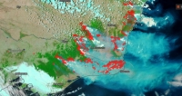
6 things to ask yourself before you share a bushfire map on social media
Jan 10, 2020 10:27 am UTC| Insights & Views Science
In recent days, many worrying bushfire maps have been circulating online, some appearing to suggest all of Australia is burning. You might have seen this example, decried by some as misleading, prompting this Instagram...

China Extends Gold Buying Streak as Reserves Surge Despite Volatile Prices

Trump Lifts 25% Tariff on Indian Goods in Strategic U.S.–India Trade and Energy Deal

Trump Signs Executive Order Threatening 25% Tariffs on Countries Trading With Iran

U.S.-India Trade Framework Signals Major Shift in Tariffs, Energy, and Supply Chains

Dow Hits 50,000 as U.S. Stocks Stage Strong Rebound Amid AI Volatility


New York Legalizes Medical Aid in Dying for Terminally Ill Patients

Trump Says “Very Good Talks” Underway on Russia-Ukraine War as Peace Efforts Continue

China Warns US Arms Sales to Taiwan Could Disrupt Trump’s Planned Visit

Trump Allows Commercial Fishing in Protected New England Waters

SpaceX Prioritizes Moon Mission Before Mars as Starship Development Accelerates

NASA and SpaceX Target Crew-11 Undocking From ISS Amid Medical Concern

Neuralink Plans High-Volume Brain Implant Production and Fully Automated Surgery by 2026

Jared Isaacman Confirmed as NASA Administrator, Becomes 15th Leader of U.S. Space Agency
Senate Sets December 8 Vote on Trump’s NASA Nominee Jared Isaacman
Nvidia CEO Jensen Huang Says AI Investment Boom Is Just Beginning as NVDA Shares Surge

Amazon Stock Rebounds After Earnings as $200B Capex Plan Sparks AI Spending Debate

Global PC Makers Eye Chinese Memory Chip Suppliers Amid Ongoing Supply Crunch

OpenAI Expands Enterprise AI Strategy With Major Hiring Push Ahead of New Business Offering

SoftBank Shares Slide After Arm Earnings Miss Fuels Tech Stock Sell-Off


- Market Data


