How to create a thriving forest, not box-checking ‘tree cover’
  How is Antarctica melting, exactly? Crucial details are beginning to come into focus
  Unsustainable – or manageable? We don’t yet know how data centres will impact Australia’s environment
  How ongoing deforestation is rooted in colonialism and its management practices
  We combed through old botanical surveys to track how plants on Australia’s islands are changing
  The world’s biggest trees could hold the secret to coping with drought
  GesiaPlatform Launches Carbon-Neutral Lifestyle App ‘Net Zero Heroes’
  LA fires: Long-term exposure to wildfire smoke is poorly understood − and a growing risk
  Lake beds are rich environmental records — studying them reveals much about a place’s history
  Ukraine minerals deal: the idea that natural resource extraction can build peace has been around for decades
  Rice feeds billions of people – but its role in fueling climate change is growing
  As the Black Summer megafires neared, people rallied to save wildlife and domestic animals. But it came at a real cost


 Add as a preferred source on Google
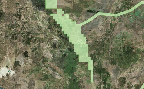



It's a 50km long patch in the middle of Queensland that's causing a lot of trouble, but many people couldn't even point it out on a map. Queensland Government - Coordinated Projects Map
The Adani Carmichael coal mine has been an election issue across state and federal politics since 2016.
Despite bipartisan support, it defined the November 2017 Queensland election, has shaped federal by-elections since and prompted protests in almost every Australian state and territory – including a convoy that has made its way up to the neighbouring town of Clermont all the way from Tasmania.
So given it’s gone through several revisions thanks to issues with funding and environmental approvals, what does the proposed mine look like now?
This is a heavily revised version of the graphic originally created for the 2017 Queensland state election.
It will be updated as new information becomes available.